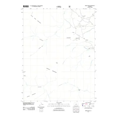
2011 Map of Windy Peak
USGS Topo · Published 2011About this map
Windy Peak rises over a high-altitude landscape where the Platte River Mountains, Kenosha Mountains, and Tarryall Mountains converge in Jefferson County. This terrain is defined by its drainage systems and geological deposits, notably the Lone and Lonesome Lodes Pegmatite Mine and Aspen Lode Pegmatite Mine situated near Wellington Rd. These mining sites, along with the Wire Patch Mine to the west, reflect the area's history of mineral exploration.
Find a feature on this map
29 named features on this map. Tap any name to fly to it.
Don’t see what you’re looking for? This feature index may not catch every label — zoom into the map to look around manually.
Map Details
Editions of this 2011 Windy Peak Map
This is the sole edition of this map. No revisions or reprints were ever made.
Other maps of this area

1893 · Platte Canyon
USGS Topo · 1:125,000

1945 · Pine
USGS Topo · 1:24,000

1945 · Bailey
USGS Topo · 1:24,000

1945 · Shawnee
USGS Topo · 1:24,000

1948 · Pine
USGS Topo · 1:24,000

1948 · Shawnee
USGS Topo · 1:24,000

1949 · Bailey
USGS Topo · 1:24,000

1953 · Denver
USGS Topo · 1:250,000

1954 · Green Mountain
USGS Topo · 1:24,000
1954 · Windy Peak
USGS Topo · 1:24,000