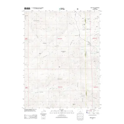
2013 Map of Windy Peak
USGS Topo · Published 2013About this map
Windy Peak rises over a high-altitude landscape defined by the drainage systems of the Pike National Forest and the Kenosha Mountains. In the early 2010s, this area of the Park and Jefferson County line maintained its character through several established ranches and recreation camps. Private holdings such as Sunnyside Ranch and Bancroft Ranch are situated near water sources like Freeman Creek, while the youth-focused Sylvania of the Rockies occupies a position near Wellington Lake Road. The region is a significant node for backcountry travelers, marked by the intersection of the Colorado Trail 1776 and the Wigwam Trail 609. These routes navigate through landmarks like Wigwam Park and East Lost Park, providing a view of the intricate gulch and meadow systems, including Refrigerator Gulch and Craig Meadows, that characterize the eastern Platte River Mountains.
Find a feature on this map
40 named features on this map. Tap any name to fly to it.
Don’t see what you’re looking for? This feature index may not catch every label — zoom into the map to look around manually.
Map Details
Editions of this 2013 Windy Peak Map
This is the sole edition of this map. No revisions or reprints were ever made.
Other maps of this area

1893 · Platte Canyon
USGS Topo · 1:125,000

1945 · Pine
USGS Topo · 1:24,000

1945 · Bailey
USGS Topo · 1:24,000

1945 · Shawnee
USGS Topo · 1:24,000

1948 · Pine
USGS Topo · 1:24,000

1948 · Shawnee
USGS Topo · 1:24,000

1949 · Bailey
USGS Topo · 1:24,000

1953 · Denver
USGS Topo · 1:250,000

1954 · Green Mountain
USGS Topo · 1:24,000
1954 · Windy Peak
USGS Topo · 1:24,000