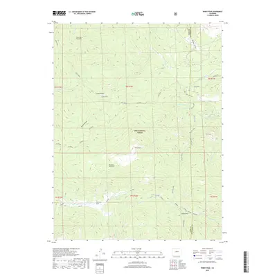
2019 Map of Windy Peak
USGS Topo · Published 2019About this map
Windy Peak rises as the central landmark of this high-elevation landscape within the Pike National Forest, straddling the boundary of Park and Jefferson Counties. The map reveals a complex network of alpine drainages, notably Payne Creek and Rolling Creek, which carve through the Platte River Mountains and the Kenosha Mountains. These summits and valleys define a wilderness character where isolated geographic markers like The Castle and East Lost Park serve as primary points of orientation.
Find a feature on this map
30 named features on this map. Tap any name to fly to it.
Don’t see what you’re looking for? This feature index may not catch every label — zoom into the map to look around manually.
Map Details
Editions of this 2019 Windy Peak Map
This is the sole edition of this map. No revisions or reprints were ever made.
Other maps of this area

1893 · Platte Canyon
USGS Topo · 1:125,000

1945 · Pine
USGS Topo · 1:24,000

1945 · Bailey
USGS Topo · 1:24,000

1945 · Shawnee
USGS Topo · 1:24,000

1948 · Pine
USGS Topo · 1:24,000

1948 · Shawnee
USGS Topo · 1:24,000

1949 · Bailey
USGS Topo · 1:24,000

1953 · Denver
USGS Topo · 1:250,000

1954 · Green Mountain
USGS Topo · 1:24,000
1954 · Windy Peak
USGS Topo · 1:24,000