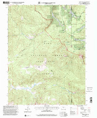
1994 Map of Windy Peak
USGS Topo · Published 2001About this map
Platte River headwaters and high-elevation drainage basins characterize this portion of the Pike National Forest during the mid-1990s. The landscape is dominated by the Tarryall Mountains and Kenosha Mountains, where the Lost Creek Wilderness preserves a network of primitive routes including the Wigwam Trail and Payne Creek Trail. While much of the terrain is dedicated to forest and wilderness, several established ranch properties sit along the eastern boundary, such as Sunnyside Ranch and Bancroft Ranch, indicating the persistent legacy of high-country ranching.
Find a feature on this map
28 named features on this map. Tap any name to fly to it.
Don’t see what you’re looking for? This feature index may not catch every label — zoom into the map to look around manually.
Map Details
Editions of this 1994 Windy Peak Map
This is the sole edition of this map. No revisions or reprints were ever made.
Other maps of this area

1893 · Platte Canyon
USGS Topo · 1:125,000

1945 · Pine
USGS Topo · 1:24,000

1945 · Bailey
USGS Topo · 1:24,000

1945 · Shawnee
USGS Topo · 1:24,000

1948 · Pine
USGS Topo · 1:24,000

1948 · Shawnee
USGS Topo · 1:24,000

1949 · Bailey
USGS Topo · 1:24,000

1953 · Denver
USGS Topo · 1:250,000

1954 · Green Mountain
USGS Topo · 1:24,000
1954 · Windy Peak
USGS Topo · 1:24,000