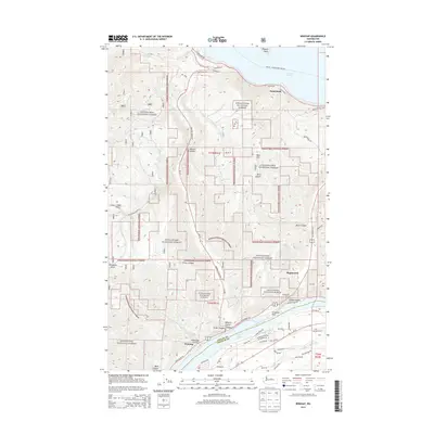
2014 Map of Winesap
USGS Topo · Published 2014About this map
Lake Chelan dominates the northern reaches of this landscape, its waters meeting the shore at Sunnybank and Wapato Point. This 2014 survey documents the complex topography of the Wenatchee National Forest, where deep incisions like Navarre Coulee and Ficher Canyon carve through the high ground. To the south, the Columbia River forms the natural boundary between Chelan and Douglas counties, widening into Lake Entiat. Small settlements and residential clusters such as Winesap and Maplecreek are connected by a network of winding roads including US Highway 97A. Significant transport landmarks like the Knapps Hill Tunnel and the Chelan - Lucerne Ferry Crossing illustrate the unique infrastructure required to navigate this terrain where massive water bodies and steep mountainsides meet.
Find a feature on this map
51 named features on this map. Tap any name to fly to it.
Don’t see what you’re looking for? This feature index may not catch every label — zoom into the map to look around manually.
Map Details
Editions of this 2014 Winesap Map
This is the sole edition of this map. No revisions or reprints were ever made.
Other maps of this area

1901 · Chelan
USGS Topo · 1:125,000

1957 · Wenatchee
USGS Topo · 1:250,000

1968 · Chelan
USGS Topo · 1:24,000

1968 · Waterville
USGS Topo · 1:24,000
1968 · Cooper Ridge
USGS Topo · 1:24,000

1968 · Entiat
USGS Topo · 1:24,000
1968 · Stormy Mtn.
USGS Topo · 1:24,000

1968 · Ardenvoir
USGS Topo · 1:24,000

1968 · Baldy Mtn
USGS Topo · 1:24,000

1968 · Winesap
USGS Topo · 1:24,000