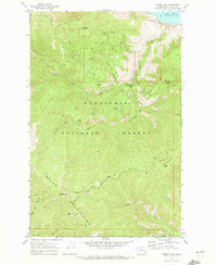
1968 Map of Stormy Mtn.
USGS Topo · Published 1972About this map
Lake Chelan edges the northeastern corner of this high-elevation terrain, where the steep slopes of the Chelan Mountains rise abruptly from the water. The landscape is dominated by the Wenatchee National Forest, defined by a network of primitive transportation routes including the Shady Pass Road, numerous unnamed pack trails, and several jeep trails. These routes connect remote landmarks like the Twentyfive Mile Creek Guard Station and prominent summits such as Stormy Mtn, Pot Peak, and Slide Peak.
Find a feature on this map
31 named features on this map. Tap any name to fly to it.
Don’t see what you’re looking for? This feature index may not catch every label — zoom into the map to look around manually.
Map Details
Editions of this 1968 Stormy Mtn. Map
3 editions found
Other maps of this area

1899 · Methow
USGS Topo · 1:125,000

1901 · Chelan
USGS Topo · 1:125,000

1901 · Methow
USGS Topo · 1:125,000

1955 · Concrete
USGS Topo · 1:250,000

1957 · Wenatchee
USGS Topo · 1:250,000

1958 · Concrete
USGS Topo · 1:250,000

1962 · Concrete
USGS Topo · 1:250,000

1968 · South Navarre Peak
USGS Topo · 1:24,000
1968 · Big Goat Mtn
USGS Topo · 1:24,000

1968 · Tyee Mtn.
USGS Topo · 1:24,000