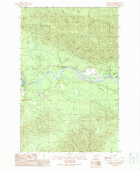
1990 Map of Winfield Creek
USGS Topo · Published 1990About this map
The Hoh River winds through this Jefferson County landscape, serving as a primary corridor through the heavily forested terrain of the late twentieth century. In this 1990 provisional survey, the boundaries between the Olympic National Park and the Olympic National Forest are clearly delineated, showing a region managed for both preservation and resource extraction. Evidence of local industry and recreational infrastructure is present, including numerous Borrow Pits and established sites like the Minnie Peterson Campground and Willoughby Creek Campground.
Find a feature on this map
31 named features on this map. Tap any name to fly to it.
Don’t see what you’re looking for? This feature index may not catch every label — zoom into the map to look around manually.
Map Details
Editions of this 1990 Winfield Creek Map
This is the sole edition of this map. No revisions or reprints were ever made.
Other maps of this area

1939 · Forks
USGS Topo · 1:62,500

1943 · Spruce Mountain
USGS Topo · 1:62,500

1943 · Copalis Beach
USGS Topo · 1:250,000

1951 · Copalis Beach
USGS Topo · 1:250,000

1956 · Destruction Island
USGS Topo · 1:62,500

1956 · Spruce Mtn.
USGS Topo · 1:62,500

1956 · Salmon River
USGS Topo · 1:62,500

1957 · Forks
USGS Topo · 1:62,500

1957 · Copalis Beach
USGS Topo · 1:250,000

1963 · Copalis Beach
USGS Topo · 1:250,000