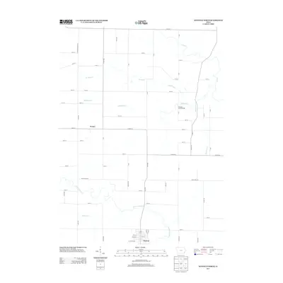
2013 Map of Winfield North
USGS Topo · Published 2013About this map
Winfield anchors the southern boundary of this Henry County landscape, where the town grid meets a network of rural routes and meandering waterways. The settlement of Wyman sits further north along the county line, situated near the headwaters of Buffington Cr. The terrain is defined by a dense drainage system that includes Big Slough Cr and the E Fork Crooked Cr, which carves a winding path through the southern portion of the quadrangle. A notable point of transit is Gripple's Quarry Bridge, crossing Buffington Cr in the eastern section. This 2013 survey illustrates the modern configuration of Louisa and Henry County roads, such as CO Hwy-W66 and CO Road G62, which overlie an older agricultural patchwork. Researchers will find a detailed representation of how these creeks and seasonal runs, including Spring Run Cr and Phillips Cr, dictate the placement of farms and local infrastructure.
Find a feature on this map
58 named features on this map. Tap any name to fly to it.
Don’t see what you’re looking for? This feature index may not catch every label — zoom into the map to look around manually.
Map Details
Editions of this 2013 Winfield North Map
This is the sole edition of this map. No revisions or reprints were ever made.
Other maps of this area

1958 · Davenport
USGS Topo · 1:250,000

1961 · Davenport
USGS Topo · 1:250,000

1962 · Davenport
USGS Topo · 1:250,000

1970 · Cotter
USGS Topo · 1:24,000
1970 · Columbus Junction
USGS Topo · 1:24,000

1970 · Ainsworth
USGS Topo · 1:24,000
1981 · Cairo
USGS Topo · 1:24,000
1981 · Crawfordsville
USGS Topo · 1:24,000
1981 · Morning Sun
USGS Topo · 1:24,000
1981 · Winfield North
USGS Topo · 1:24,000