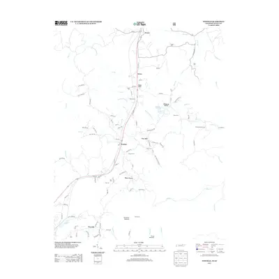
2013 Map of Winfield
USGS Topo · Published 2013About this map
Winfield serves as the central hub of this Scott County landscape, situated along the corridor of Old US Hwy 27. The geography is defined by the State Line between Tennessee and Kentucky, where the settlement of Isham sits directly on the border north of Winfield. This area is characterized by a dense network of family-named cemeteries, including Chitwood Cem, Isham Cem, and Stephens Cem, which offer significant value for genealogical research. The terrain is shaped by the winding paths of Roaring Paunch Cr and Jellico Cr, with elevations rising toward Honeycutt Mountain and Privet Mountain in the south. Smaller communities such as Piney Grove and Clay Hill are linked by a series of hollow roads and trails, including Bart Grant Hollow Rd and Thompson Trl, reflecting the region’s rural development pattern and traditional land use near the state border.
Find a feature on this map
99 named features on this map. Tap any name to fly to it.
Don’t see what you’re looking for? This feature index may not catch every label — zoom into the map to look around manually.
Map Details
Editions of this 2013 Winfield Map
This is the sole edition of this map. No revisions or reprints were ever made.
Other maps of this area

1890 · Williamsburg
USGS Topo · 1:125,000

1893 · Briceville
USGS Topo · 1:125,000

1894 · Williamsburg
USGS Topo · 1:125,000

1895 · Wartburg
USGS Topo · 1:125,000

1895 · Briceville
USGS Topo · 1:125,000

1896 · Wartburg
USGS Topo · 1:125,000

1896 · Briceville
USGS Topo · 1:125,000

1934 · Barthell
USGS Topo · 1:62,500

1936 · Pioneer
USGS Topo · 1:24,000
1946 · Pioneer
USGS Topo · 1:24,000