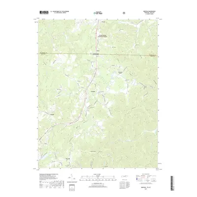
2019 Map of Winfield
USGS Topo · Published 2019About this map
Winfield serves as a central hub on the plateau, where the landscape transitions into the southern reaches of the Daniel Boone National Forest. This survey captures the intricate network of family settlements and rural cemeteries that define this section of the Kentucky-Tennessee border. Numerous burial sites, including Stephens Cem, Chitwood Cem, and Trammel Memorial Cem, are scattered across the drainages of Roaring Paunch Cr and Jellico Cr, providing a detailed record for genealogical research. The terrain is marked by significant elevations like Honeycutt Mtn and Privet Mtn, which overlook the deep-cut valleys of Reed Hollow and Raven Hollow. The proximity of the border is evident at Isham, where the state line bisects the community, illustrating the shared geography and history of Scott County and McCreary County.
Find a feature on this map
94 named features on this map. Tap any name to fly to it.
Don’t see what you’re looking for? This feature index may not catch every label — zoom into the map to look around manually.
Map Details
Editions of this 2019 Winfield Map
This is the sole edition of this map. No revisions or reprints were ever made.
Other maps of this area

1890 · Williamsburg
USGS Topo · 1:125,000

1893 · Briceville
USGS Topo · 1:125,000

1894 · Williamsburg
USGS Topo · 1:125,000

1895 · Wartburg
USGS Topo · 1:125,000

1895 · Briceville
USGS Topo · 1:125,000

1896 · Wartburg
USGS Topo · 1:125,000

1896 · Briceville
USGS Topo · 1:125,000

1934 · Barthell
USGS Topo · 1:62,500

1936 · Pioneer
USGS Topo · 1:24,000
1946 · Pioneer
USGS Topo · 1:24,000