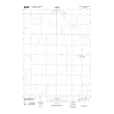
2010 Map of Winfield South
USGS Topo · Published 2010About this map
The southern portion of Winfield and the settlement of Mount Union anchor this survey of rural Henry County, Iowa. The landscape is defined by a rigorous section-line road grid, including Marsh Ave and Racine Ave, which segments the fertile agricultural land. This drainage pattern is shaped by several meandering waterways such as East Fork Crooked Creek and North Branch Big Creek, which cut across the geometric property lines. Local history is preserved in several small burial grounds scattered throughout the township, including Tallman Cemetery, Sheridan Cemetery, and Trinity Cemetery. The village of Mount Union is shown with its street plan and the Mount Union Post Office, serving as a localized hub for the surrounding farmsteads. To the north, the Winfield and Scott Cemetery sits near the edge of the larger community of Winfield, reflecting the long-established social fabric of this prairie region.
Find a feature on this map
31 named features on this map. Tap any name to fly to it.
Don’t see what you’re looking for? This feature index may not catch every label — zoom into the map to look around manually.
Map Details
Editions of this 2010 Winfield South Map
This is the sole edition of this map. No revisions or reprints were ever made.
Other maps of this area

1958 · Burlington
USGS Topo · 1:250,000

1958 · Davenport
USGS Topo · 1:250,000

1961 · Burlington
USGS Topo · 1:250,000

1961 · Davenport
USGS Topo · 1:250,000

1962 · Davenport
USGS Topo · 1:250,000

1963 · Burlington
USGS Topo · 1:250,000
1981 · Cairo
USGS Topo · 1:24,000

1981 · Mount Pleasant
USGS Topo · 1:24,000
1981 · Crawfordsville
USGS Topo · 1:24,000
1981 · Morning Sun
USGS Topo · 1:24,000