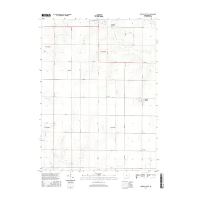
2015 Map of Winfield South
USGS Topo · Published 2015About this map
Winfield and Mount Union anchor this detailed landscape in northern Henry County, showcasing a meticulously gridded agricultural corridor. The terrain is defined by the winding paths of several waterways, most notably the East Fork Crooked Creek and N Br Big Cr, which intersect the section lines and gravel roads that dominate the region. Genealogists will find significant value in the distribution of rural burial grounds, including Tallman Cem, Sheridan Cem, and Trinity Cem, which are often the last standing markers of early family landholdings in the township.
Find a feature on this map
41 named features on this map. Tap any name to fly to it.
Don’t see what you’re looking for? This feature index may not catch every label — zoom into the map to look around manually.
Map Details
Editions of this 2015 Winfield South Map
This is the sole edition of this map. No revisions or reprints were ever made.
Other maps of this area

1958 · Burlington
USGS Topo · 1:250,000

1958 · Davenport
USGS Topo · 1:250,000

1961 · Burlington
USGS Topo · 1:250,000

1961 · Davenport
USGS Topo · 1:250,000

1962 · Davenport
USGS Topo · 1:250,000

1963 · Burlington
USGS Topo · 1:250,000
1981 · Cairo
USGS Topo · 1:24,000

1981 · Mount Pleasant
USGS Topo · 1:24,000
1981 · Crawfordsville
USGS Topo · 1:24,000
1981 · Morning Sun
USGS Topo · 1:24,000