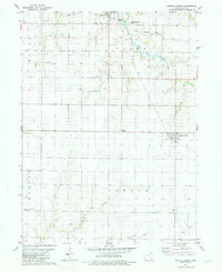
1981 Map of Winfield South
USGS Topo · Published 1981About this map
The agricultural landscape of northern Henry County is anchored by Mount Union and the southern edge of Winfield in this early 1980s USGS survey. The territory is clearly divided into the civil townships of Wayne, Scott, Canaan, and Marion, revealing a rural settlement pattern defined by isolated farmsteads and historic community centers. Genealogists will find significant local landmarks such as Wesley Chapel and the Pleasant Lawn Sch, alongside well-documented burial grounds including Sheridan Cem and the Winfield and Scott Cem.
Find a feature on this map
19 named features on this map. Tap any name to fly to it.
Don’t see what you’re looking for? This feature index may not catch every label — zoom into the map to look around manually.
Map Details
Editions of this 1981 Winfield South Map
This is the sole edition of this map. No revisions or reprints were ever made.
Other maps of this area

1958 · Burlington
USGS Topo · 1:250,000

1958 · Davenport
USGS Topo · 1:250,000

1961 · Burlington
USGS Topo · 1:250,000

1961 · Davenport
USGS Topo · 1:250,000

1962 · Davenport
USGS Topo · 1:250,000

1963 · Burlington
USGS Topo · 1:250,000
1981 · Cairo
USGS Topo · 1:24,000

1981 · Mount Pleasant
USGS Topo · 1:24,000
1981 · Crawfordsville
USGS Topo · 1:24,000
1981 · Morning Sun
USGS Topo · 1:24,000