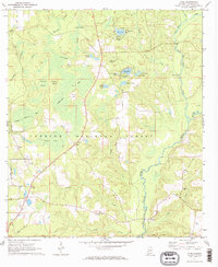
1971 Map of Wing
USGS Topo · Published 1973About this map
The Conecuh National Forest dominates this section of Covington County, where the landscape is defined by a dense network of swampy branches and named ponds. Small settlements such as Wing, Falco, and Beda anchor the rural infrastructure, connected by winding secondary roads and paths that lead to local gathering places like Mt Hermon Ch and Zion Rock Ch. The terrain is notably water-heavy, featuring numerous isolated basins like Alligator Pond, Blue Pond, and Open Pond, which includes a dedicated Open Pond Lookout Tower.
Find a feature on this map
43 named features on this map. Tap any name to fly to it.
Don’t see what you’re looking for? This feature index may not catch every label — zoom into the map to look around manually.
Map Details
Editions of this 1971 Wing Map
2 editions found

Other maps of this area

1949 · Crestview
USGS Topo · 1:62,500

1949 · Laurel Hill
USGS Topo · 1:62,500

1950 · Laurel Hill
USGS Topo · 1:62,500

1951 · Crestview
USGS Topo · 1:62,500

1953 · Andalusia
USGS Topo · 1:250,000

1957 · Andalusia
USGS Topo · 1:250,000

1957 · Pensacola
USGS Topo · 1:250,000

1959 · Pensacola
USGS Topo · 1:250,000

1960 · Pensacola
USGS Topo · 1:250,000

1971 · Dixie
USGS Topo · 1:24,000