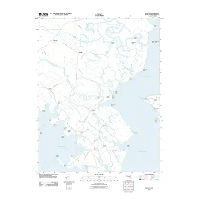
2011 Map of Wingate
USGS Topo · Published 2011About this map
Bishops Head and Wingate anchor this coastal landscape in the lower Dorchester County marshes, where the land fragmentizes into a complex network of guts, coves, and points. The area is defined by its relationship with Fishing Bay and the Honga River, with small settlements like Toddville connected by narrow corridors of high ground. Local history is preserved in sites such as Ebenezer Cemetery and Zion Cemetery, while the presence of multiple local post offices—including the Elliott Post Office—highlights the historical autonomy of these water-bound communities.
Find a feature on this map
83 named features on this map. Tap any name to fly to it.
Don’t see what you’re looking for? This feature index may not catch every label — zoom into the map to look around manually.
Map Details
Editions of this 2011 Wingate Map
This is the sole edition of this map. No revisions or reprints were ever made.
Other maps of this area

1898 · St. Marys
USGS Topo · 1:125,000

1903 · Nanticoke
USGS Topo · 1:62,500

1903 · Bloodsworth Island
USGS Topo · 1:62,500

1903 · Deal Island
USGS Topo · 1:62,500

1905 · Crapo
USGS Topo · 1:62,500

1906 · St. Marys
USGS Topo · 1:125,000

1942 · Bloodsworth Island
USGS Topo · 1:24,000

1942 · Richland Point
USGS Topo · 1:24,000
1942 · Honga
USGS Topo · 1:24,000

1942 · Deal Island
USGS Topo · 1:24,000