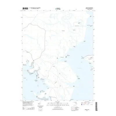
2014 Map of Wingate
USGS Topo · Published 2014About this map
Elliott Island defines this intricate Dorchester County coastal landscape, where land and water merge through a labyrinth of marshes and tidal creeks. The settlement of Elliott serves as the primary hub on the eastern shore of Fishing Bay, connected to the interior by the lone stretch of Buck Ridge Rd. Genealogical interest is anchored by several local burial sites, including Ebenezer Cem, Zion Cem, and Elliotts Cem, which provide clues to the families who have inhabited these necks and ridges for generations.
Find a feature on this map
50 named features on this map. Tap any name to fly to it.
Don’t see what you’re looking for? This feature index may not catch every label — zoom into the map to look around manually.
Map Details
Editions of this 2014 Wingate Map
This is the sole edition of this map. No revisions or reprints were ever made.
Other maps of this area

1898 · St. Marys
USGS Topo · 1:125,000

1903 · Nanticoke
USGS Topo · 1:62,500

1903 · Bloodsworth Island
USGS Topo · 1:62,500

1903 · Deal Island
USGS Topo · 1:62,500

1905 · Crapo
USGS Topo · 1:62,500

1906 · St. Marys
USGS Topo · 1:125,000

1942 · Bloodsworth Island
USGS Topo · 1:24,000

1942 · Richland Point
USGS Topo · 1:24,000
1942 · Honga
USGS Topo · 1:24,000

1942 · Deal Island
USGS Topo · 1:24,000