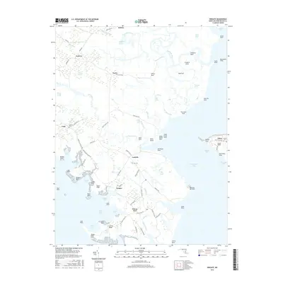
2016 Map of Wingate
USGS Topo · Published 2016About this map
The low-lying archipelago of Dorchester County's marshes defines this coastal landscape, where life is governed by the tides of the Chesapeake Bay and Fishing Bay. Small fishing communities and hamlets such as Wingate, Toddville, and Bishops Head are connected by narrow roads like Toddville Rd and Wingate Bishops Head Rd that thread through the Great Marsh and past Edgars Ridge. The map shows a precarious balance between land and water, with extensive wetlands like the Raccoon Creek Marsh and Thorofare Marsh surrounding isolated points of higher ground such as Sugarloaf and Willey Neck. Local history is preserved in small burial grounds including Ebenezer Cem near Crapo and the Elliott Cem on the eastern shore of the quadrangle. The intricate shoreline of McCreadys Cove, Negro Cove, and Wingate Cove reflects the area's deep maritime heritage and its reliance on the complex network of tidal guts and creeks.
Find a feature on this map
107 named features on this map. Tap any name to fly to it.
Don’t see what you’re looking for? This feature index may not catch every label — zoom into the map to look around manually.
Map Details
Editions of this 2016 Wingate Map
This is the sole edition of this map. No revisions or reprints were ever made.
Other maps of this area

1898 · St. Marys
USGS Topo · 1:125,000

1903 · Nanticoke
USGS Topo · 1:62,500

1903 · Bloodsworth Island
USGS Topo · 1:62,500

1903 · Deal Island
USGS Topo · 1:62,500

1905 · Crapo
USGS Topo · 1:62,500

1906 · St. Marys
USGS Topo · 1:125,000

1942 · Bloodsworth Island
USGS Topo · 1:24,000

1942 · Richland Point
USGS Topo · 1:24,000
1942 · Honga
USGS Topo · 1:24,000

1942 · Deal Island
USGS Topo · 1:24,000