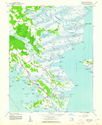
1942 Map of Wingate
USGS Topo · Published 1962About this map
Blackwater River and the complex tidal marshes of Dorchester County dominate this 1942 landscape, where the land and water are inextricably linked. Small fishing and farming outposts like Toddville and Wingate are connected by a thin network of roads that navigate the vast wetlands, leading to remote spots like Wingate PO and Bishops Head. The map shows a region shaped by its waterways, from the narrow passages of Tedious Creek and Hearns Creek to the broader reaches of Stingaree Bend. This topography reveals the traditional isolated character of the Chesapeake’s eastern shore before modern infrastructure altered local travel. Extensive marshlands such as Raccoon Creek Marsh and the Beech Ground Swamp highlight the environmental challenges faced by early residents, while the isolated Elliott Island sits separated by the wide fishing grounds of the bay, accessible only through these intricate tidal channels.
Find a feature on this map
90 named features on this map. Tap any name to fly to it.
Don’t see what you’re looking for? This feature index may not catch every label — zoom into the map to look around manually.
Map Details
Editions of this 1942 Wingate Map
2 editions found
Other maps of this area

1898 · St. Marys
USGS Topo · 1:125,000

1903 · Nanticoke
USGS Topo · 1:62,500

1903 · Bloodsworth Island
USGS Topo · 1:62,500

1903 · Deal Island
USGS Topo · 1:62,500

1905 · Crapo
USGS Topo · 1:62,500

1906 · St. Marys
USGS Topo · 1:125,000

1942 · Bloodsworth Island
USGS Topo · 1:24,000

1942 · Richland Point
USGS Topo · 1:24,000
1942 · Honga
USGS Topo · 1:24,000

1942 · Deal Island
USGS Topo · 1:24,000