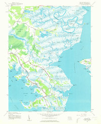
1942 Map of Wingate
USGS Topo · Published 1962About this map
Blackwater River and the complex tidal marshes of Dorchester County dominate this 1942 survey, depicting a landscape defined by water and narrow ridges of habitable land. Small fishing and farming communities like Toddville, Bishops Head, and Crapo are linked by a singular road network that skirts the Great Marsh and Cedar Creek Marsh. The map provides a detailed view of the Eastern Shore's amphibious geography, where names like Wrights Landing and Stingaree Island speak to a long history of maritime activity. In the east, the isolated settlement of Elliott on Elliott Island sits between Fishing Bay and the Transquaking River, demonstrating the extreme reliance on favorable topography in this low-lying region. This survey, mapped by the Army Map Service during the war years, documents the intricate drainage patterns of Raccoon Creek and numerous guts and ditches before mid-century environmental changes.
Find a feature on this map
87 named features on this map. Tap any name to fly to it.
Don’t see what you’re looking for? This feature index may not catch every label — zoom into the map to look around manually.
Map Details
Editions of this 1942 Wingate Map
2 editions found
Other maps of this area

1898 · St. Marys
USGS Topo · 1:125,000

1903 · Nanticoke
USGS Topo · 1:62,500

1903 · Bloodsworth Island
USGS Topo · 1:62,500

1903 · Deal Island
USGS Topo · 1:62,500

1905 · Crapo
USGS Topo · 1:62,500

1906 · St. Marys
USGS Topo · 1:125,000

1942 · Bloodsworth Island
USGS Topo · 1:24,000

1942 · Richland Point
USGS Topo · 1:24,000
1942 · Honga
USGS Topo · 1:24,000

1942 · Deal Island
USGS Topo · 1:24,000