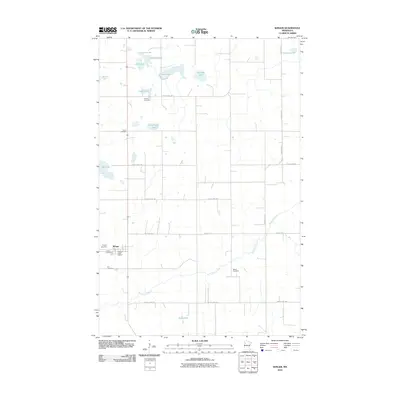
2010 Map of Winger
USGS Topo · Published 2010About this map
Winger serves as the primary hub of this agricultural landscape in Polk County, concentrated around the Winger Post Office and a cluster of local landmarks. The area's cultural history is deeply rooted in its rural parish sites, evidenced by numerous burial grounds including Winger Cemetery, Calvary Cemetery, and Elm Cemetery. The landscape is defined by the meandering course of the Sand Hill River, which cuts diagonally across the southern half of the quadrangle, while the northern territory is dotted with glacial waters such as Engemoen Lake, Gosen Lake, and Bradley Lake. A rigid grid of section roads and thoroughfares like County Hwy-1 and County Hwy-206 connects these isolated water bodies and family-named cemeteries like Dovre Cemetery and Gosen Cemetery, illustrating the systematic land division and settlement patterns of this northern Minnesota region.
Find a feature on this map
28 named features on this map. Tap any name to fly to it.
Don’t see what you’re looking for? This feature index may not catch every label — zoom into the map to look around manually.
Map Details
Editions of this 2010 Winger Map
This is the sole edition of this map. No revisions or reprints were ever made.
Other maps of this area

1919 · Valley
USGS Topo · 1:62,500

1952 · Grand Forks
USGS Topo · 1:250,000

1954 · Bemidji
USGS Topo · 1:250,000

1956 · Grand Forks
USGS Topo · 1:250,000

1957 · Bemidji
USGS Topo · 1:250,000

1958 · Bemidji
USGS Topo · 1:250,000

1966 · Grand Forks
USGS Topo · 1:250,000

1966 · Union Lake
USGS Topo · 1:24,000
1966 · Erskine
USGS Topo · 1:24,000
1966 · Faith NE
USGS Topo · 1:24,000