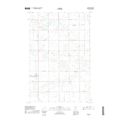
2019 Map of Winger
USGS Topo · Published 2019About this map
Winger serves as the primary hub for this portion of Polk County, situated at the junction of local routes like Minnesota Ave and Dakota Ave. The surrounding landscape is defined by the meandering course of the Sand Hill River, which cuts across the southern half of the quadrangle. This area is characterized by a high density of small, named lakes and wetlands, indicative of the region's glacial legacy. Significant water bodies such as Johnson Lake, Hedman Lake, and Gosen Lake are interspersed with smaller prairie potholes.
Find a feature on this map
33 named features on this map. Tap any name to fly to it.
Don’t see what you’re looking for? This feature index may not catch every label — zoom into the map to look around manually.
Map Details
Editions of this 2019 Winger Map
This is the sole edition of this map. No revisions or reprints were ever made.
Other maps of this area

1919 · Valley
USGS Topo · 1:62,500

1952 · Grand Forks
USGS Topo · 1:250,000

1954 · Bemidji
USGS Topo · 1:250,000

1956 · Grand Forks
USGS Topo · 1:250,000

1957 · Bemidji
USGS Topo · 1:250,000

1958 · Bemidji
USGS Topo · 1:250,000

1966 · Grand Forks
USGS Topo · 1:250,000

1966 · Union Lake
USGS Topo · 1:24,000
1966 · Erskine
USGS Topo · 1:24,000
1966 · Faith NE
USGS Topo · 1:24,000