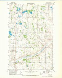
1969 Map of Winger
USGS Topo · Published 1971About this map
Winger serves as the primary hub in this late 1960s landscape, positioned at the junction of the Soo Line railroad and local transport routes. The surrounding terrain is a complex of wetlands and glacial lakes, including Foot Lake, Hedman Lake, and Johnson Lake, much of which is conserved within a National Wildlife Management Area. The map reveals a deeply rooted agricultural and religious community, evidenced by several country cemeteries and churches such as Dovre Cem, Elm Cem, and Bethel Ch.
Find a feature on this map
30 named features on this map. Tap any name to fly to it.
Don’t see what you’re looking for? This feature index may not catch every label — zoom into the map to look around manually.
Map Details
Editions of this 1969 Winger Map
This is the sole edition of this map. No revisions or reprints were ever made.
Other maps of this area

1919 · Valley
USGS Topo · 1:62,500

1952 · Grand Forks
USGS Topo · 1:250,000

1954 · Bemidji
USGS Topo · 1:250,000

1956 · Grand Forks
USGS Topo · 1:250,000

1957 · Bemidji
USGS Topo · 1:250,000

1958 · Bemidji
USGS Topo · 1:250,000

1966 · Grand Forks
USGS Topo · 1:250,000

1966 · Union Lake
USGS Topo · 1:24,000
1966 · Erskine
USGS Topo · 1:24,000
1966 · Faith NE
USGS Topo · 1:24,000