
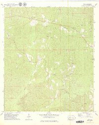
1978 Map of Winn
USGS Topo · Published 1979About this map
Winn and Clarksville anchor this rural landscape in Clarke County during the late 1970s, a region defined by its dispersed religious and community landmarks. The area's social fabric is visible through a high density of country churches and family burial grounds, including Greater Ebenezer Ch, St Lukes Ch, and the Church of God Cem. This pattern of small, localized congregations and cemeteries like Cobb Cem and Bumpers Cem suggests a long-standing settlement history rooted in family landholdings and community ties.
Find a feature on this map
26 named features on this map. Tap any name to fly to it.
Don’t see what you’re looking for? This feature index may not catch every label — zoom into the map to look around manually.
Map Details
Editions of this 1978 Winn Map
2 editions found
Other maps of this area

1953 · Andalusia
USGS Topo · 1:250,000

1953 · Hattiesburg
USGS Topo · 1:250,000

1957 · Andalusia
USGS Topo · 1:250,000

1958 · Hattiesburg
USGS Topo · 1:250,000

1971 · Coffeeville
USGS Topo · 1:24,000

1972 · Tattlersville
USGS Topo · 1:24,000

1972 · St. Stephens
USGS Topo · 1:24,000

1978 · Jackson
USGS Topo · 1:24,000

1978 · McEntyre
USGS Topo · 1:24,000
1978 · Grove Hill
USGS Topo · 1:24,000