
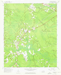
1943 Map of Winnabow
USGS Topo · Published 1962About this map
Winnabow and the surrounding rural landscape of Brunswick County appear in this mid-century survey as a collection of scattered crossroads and agrarian outposts. The interior is dominated by the Little Green Swamp, a dense wetland system feeding several winding watercourses including Town Creek and Rice Creek. Transportation in this era is defined by transitioning infrastructure, most notably the long Abandoned Railroad Grade stretching northeast toward Lanvale. This old line, once vital for the region's timber or agriculture, was already a relic by the time of the 1943 planetable surveys.
Find a feature on this map
36 named features on this map. Tap any name to fly to it.
Don’t see what you’re looking for? This feature index may not catch every label — zoom into the map to look around manually.
Map Details
Editions of this 1943 Winnabow Map
2 editions found
Other maps of this area

1942 · Wilmington
USGS Topo · 1:62,500

1943 · Funston
USGS Topo · 1:24,000

1943 · Bolivia
USGS Topo · 1:24,000

1943 · Lewis Swamp
USGS Topo · 1:24,000

1944 · Bolivia
USGS Topo · 1:31,680

1944 · Winnabow
USGS Topo · 1:31,680

1944 · Lewis Swamp
USGS Topo · 1:31,680

1947 · Rocky Point
USGS Topo · 1:62,500

1948 · Wilmington
USGS Topo · 1:62,500

1950 · Winnabow
USGS Topo · 1:25,000