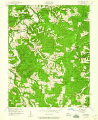
1954 Map of Winnipeg
USGS Topo · Published 1959About this map
The Gasconade River winds through the northern portion of this mid-century landscape, carving deep valleys into the terrain within the Mark Twain National Forest. This 1954 survey captures several small Ozark communities including Winnipeg, Nebo, and Kuhn, along with their local landmarks such as Winnipeg Church and Cedar Bluff Church. The mapping records a significant transition in rural education, specifically labeling several facilities like Morehouse School, Success School, and Central School as no longer in use, reflecting the consolidation of rural districts during this era.
Find a feature on this map
35 named features on this map. Tap any name to fly to it.
Don’t see what you’re looking for? This feature index may not catch every label — zoom into the map to look around manually.
Map Details
Editions of this 1954 Winnipeg Map
2 editions found
Other maps of this area

1931 · Manes
USGS Topo · 1:48,000

1941 · Big Piney
USGS Topo · 1:62,500

1941 · Manes
USGS Topo · 1:62,500

1941 · Bado
USGS Topo · 1:62,500

1943 · Big Piney
USGS Topo · 1:62,500

1943 · Manes
USGS Topo · 1:62,500

1943 · Drynob
USGS Topo · 1:62,500

1943 · Bado
USGS Topo · 1:62,500

1954 · Springfield
USGS Topo · 1:250,000

1954 · Drynob
USGS Topo · 1:62,500