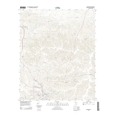
2014 Map of Winnsboro
USGS Topo · Published 2014About this map
Winnsboro serves as the primary hub of this Fairfield County landscape, where established street grids like N Congress St and Peays Ferry Rd anchor the community's layout. To the north, the small settlements of White Oak and Adger maintain a rural character, connected by a network of historic thoroughfares including the Old Chester Hwy and Mobley Hwy. The terrain is defined by a dense drainage network of creeks, such as Big Wateree Cr, Gaydens Cr, and McCulley Cr, which feed into local landmarks like the White Oak Conference Center Lake. For genealogists, the map is particularly useful for locating family plots and historical burial grounds, including Oaklawn Cem, Bethlehem Cem, and the more remote Mt Olivet Cem.
Find a feature on this map
72 named features on this map. Tap any name to fly to it.
Don’t see what you’re looking for? This feature index may not catch every label — zoom into the map to look around manually.
Map Details
Editions of this 2014 Winnsboro Map
This is the sole edition of this map. No revisions or reprints were ever made.
Other maps of this area

1904 · Columbia
USGS Topo · 1:125,000

1941 · Spartanburg
USGS Topo · 1:250,000

1942 · Camden
USGS Topo · 1:125,000

1953 · Spartanburg
USGS Topo · 1:250,000

1960 · Spartanburg
USGS Topo · 1:250,000

1963 · Spartanburg
USGS Topo · 1:250,000

1964 · Spartanburg
USGS Topo · 1:250,000

1968 · Blackstock
USGS Topo · 1:24,000
1969 · Great Falls
USGS Topo · 1:24,000

1969 · Lebanon
USGS Topo · 1:24,000