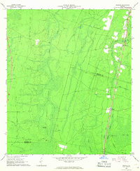
1966 Map of Winokur
USGS Topo · Published 1967About this map
Okefenokee Swamp defines the western reaches of this South Georgia landscape, where the shifting boundary between Brantley Co and Charlton Co cuts through dense wetlands and hammocks. The settlement of Winokur serves as a focal point along the Seaboard Coast Line railroad, which runs parallel to U.S. Route 301. To the north, the small community of Claypit and Bachlott Ch represent the sparse rural development of the mid-1960s.
Find a feature on this map
21 named features on this map. Tap any name to fly to it.
Don’t see what you’re looking for? This feature index may not catch every label — zoom into the map to look around manually.
Map Details
Editions of this 1966 Winokur Map
2 editions found
Other maps of this area

1917 · Nahunta
USGS Topo · 1:62,500

1917 · Boulogne
USGS Topo · 1:62,500

1918 · Folkston
USGS Topo · 1:62,500

1918 · Nahunta
USGS Topo · 1:62,500

1919 · Boulogne
USGS Topo · 1:62,500

1946 · Brunswick
USGS Topo · 1:250,000

1948 · Jacksonville
USGS Topo · 1:250,000

1948 · Brunswick
USGS Topo · 1:250,000

1953 · Waycross
USGS Topo · 1:250,000

1954 · Valdosta
USGS Topo · 1:250,000