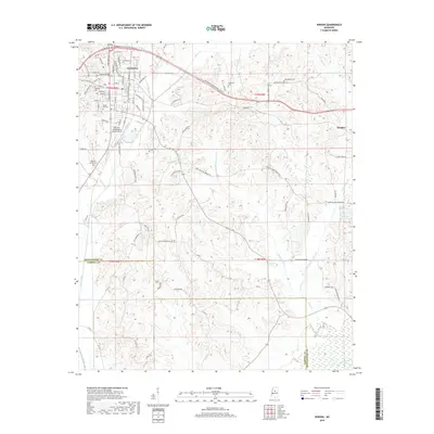
2018 Map of Winona
USGS Topo · Published 2018About this map
Winona serves as the focal point of this Montgomery County landscape, where the intersection of traditional neighborhoods and modern transit routes like Dr Martin Luther King Jr Blvd and Old Hwy 82 E are clearly defined. The town's historic footprint is anchored by several burial grounds including Oakwood Cem and Forest Hill Cem, while the Winona-Montgomery County Airport marks the southwestern expansion of the community's infrastructure.
Find a feature on this map
90 named features on this map. Tap any name to fly to it.
Don’t see what you’re looking for? This feature index may not catch every label — zoom into the map to look around manually.
Map Details
Editions of this 2018 Winona Map
This is the sole edition of this map. No revisions or reprints were ever made.
Other maps of this area

1953 · West Point
USGS Topo · 1:250,000

1954 · Duck Hill
USGS Topo · 1:62,500

1954 · McCarley
USGS Topo · 1:62,500

1958 · West Point
USGS Topo · 1:250,000

1963 · West Point
USGS Topo · 1:250,000

1966 · Kilmichael
USGS Topo · 1:24,000

1966 · Poplar Creek
USGS Topo · 1:24,000

1966 · Winona
USGS Topo · 1:24,000
1966 · Vaiden
USGS Topo · 1:24,000

1968 · Winona
USGS Topo · 1:62,500