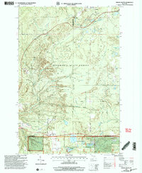
1999 Map of Winona South
USGS Topo · Published 2004About this map
The settlement of Winona and its surrounding timberlands are defined by the intersection of copper mining history and modern forest management. Located along the boundary of Ontonagon and Houghton Counties, the landscape bears the imprint of industrial activity with labels for a Mine Shaft, Gravel Pit, and extensive Tailings near the headwaters of the Elm River. These industrial features contrast with the protected lands of the Mishwabic State Forest and Ottawa National Forest, which encompass much of the southern and central terrain. Local genealogists may find interest in the Woodland Cemetery near Woodland Cem Lake, while the presence of the Simar Landing Strip and the Ontonagon Equestrian Complex indicates the area's later shift toward recreation and aviation. The hydrologic network is dense, featuring the winding Misery River and numerous glacial lakes like Courtney Lake and Sixmile Lake.
Find a feature on this map
33 named features on this map. Tap any name to fly to it.
Don’t see what you’re looking for? This feature index may not catch every label — zoom into the map to look around manually.
Map Details
Editions of this 1999 Winona South Map
This is the sole edition of this map. No revisions or reprints were ever made.
Other maps of this area

1949 · Rockland
USGS Topo · 1:62,500

1950 · Greenland
USGS Topo · 1:62,500

1951 · Rockland
USGS Topo · 1:62,500

1951 · Greenland
USGS Topo · 1:62,500

1954 · Rousseau
USGS Topo · 1:62,500

1954 · Winona
USGS Topo · 1:62,500

1958 · Iron River
USGS Topo · 1:250,000

1960 · Iron River
USGS Topo · 1:250,000

1961 · Iron River
USGS Topo · 1:250,000

1967 · Iron River
USGS Topo · 1:250,000