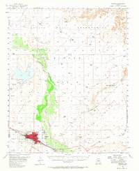
1954 Map of Winslow
USGS Topo · Published 1968About this map
The Winslow urban center and its mid-century expansion into Bushman Acres dominate the southwestern corner of this survey, where the Atchison Topeka and Santa Fe railroad serves as a primary industrial artery. To the north, the Navajo Indian Reservation landscape is marked by the meandering path of the Little Colorado River, providing a stark contrast between the grid-patterned city and the expansive open range. This era shows a community in transition, balancing its traditional ranching roots at places like Rincon Ranch with modern infrastructure such as the Winslow Municipal Airport, a Drive-in Theater, and the Radio Sta (KVNC). High plateaus like Tucker Mesa and Ives Mesa overlook the surrounding washes, while local industry is evidenced by a Gravel Pit and Quarry near the riverbanks.
Find a feature on this map
34 named features on this map. Tap any name to fly to it.
Don’t see what you’re looking for? This feature index may not catch every label — zoom into the map to look around manually.
Map Details
Editions of this 1954 Winslow Map
2 editions found
Other maps of this area

1883 · Tusayan
USGS Topo · 1:250,000

1886 · Tusayan
USGS Topo · 1:250,000

1886 · Holbrook
USGS Topo · 1:250,000

1893 · Holbrook
USGS Topo · 1:250,000

1947 · Flagstaff
USGS Topo · 1:250,000

1954 · Winslow
USGS Topo · 1:62,500

1954 · Winslow 4 NW
USGS Topo · 1:24,000

1954 · Winslow 4 SW
USGS Topo · 1:24,000

1954 · Winslow 4 SE
USGS Topo · 1:24,000

1954 · Winslow 4 NE
USGS Topo · 1:24,000