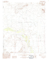
1986 Map of Winslow NW
USGS Topo · Published 1986About this map
The Navajo Indian Reservation covers the northern reaches of this landscape, where the ephemeral Coyote Wash cuts through high desert terrain. To the south, the Little Colorado River winds through a broad alluvial corridor, flanked by the Toltec Divide and the expansive Rincon Basin. This 1986 survey documents a sparsely settled ranching environment, centered on landmarks like the Rincon Ranch and several corrals scattered across the basin floors.
Find a feature on this map
13 named features on this map. Tap any name to fly to it.
Don’t see what you’re looking for? This feature index may not catch every label — zoom into the map to look around manually.
Map Details
Editions of this 1986 Winslow NW Map
This is the sole edition of this map. No revisions or reprints were ever made.
Other maps of this area

1883 · Tusayan
USGS Topo · 1:250,000

1886 · Tusayan
USGS Topo · 1:250,000

1947 · Flagstaff
USGS Topo · 1:250,000

1954 · Winslow
USGS Topo · 1:62,500

1954 · Winslow 4 NW
USGS Topo · 1:24,000

1954 · Winslow 4 SW
USGS Topo · 1:24,000

1954 · Winslow 4 SE
USGS Topo · 1:24,000

1954 · Winslow 4 NE
USGS Topo · 1:24,000

1954 · Flagstaff
USGS Topo · 1:250,000

1955 · Leupp
USGS Topo · 1:62,500