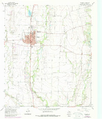
1967 Map of Winters
USGS Topo · Published 1988About this map
Winters serves as a hub of activity in this West Texas landscape, defined by a distinct urban grid that includes a Hospital, High School, and essential municipal infrastructure like the Filtration Plant and Sewage Disposal. The town's connection to the wider region is anchored by the Union Pacific railroad, which runs parallel to the meandering course of Bluff Creek. The surrounding terrain is marked by the presence of an Oil Field, with numerous wells scattered across the ranch land and rolling plains. Local recreation and community life are evidenced by the Winters Country Club and the Athletic Field, while the Drive-in Theatre south of town offers a glimpse into mid-century social habits. Water management is a key feature of the area, seen in the reservoir system of Old Lake Winters and its Spillway, providing a vital resource for this semi-arid region.
Find a feature on this map
31 named features on this map. Tap any name to fly to it.
Don’t see what you’re looking for? This feature index may not catch every label — zoom into the map to look around manually.
Map Details
Editions of this 1967 Winters Map
2 editions found
Other maps of this area

1890 · Abilene
USGS Topo · 1:125,000

1891 · Hayrick
USGS Topo · 1:125,000

1892 · Abilene
USGS Topo · 1:125,000

1892 · Ballinger
USGS Topo · 1:125,000

1893 · Sweetwater
USGS Topo · 1:125,000

1894 · Hayrick
USGS Topo · 1:125,000

1921 · Hatchel
USGS Topo · 1:31,680

1921 · Quarry Creek
USGS Topo · 1:31,680

1954 · Brownwood
USGS Topo · 1:250,000

1954 · Big Spring
USGS Topo · 1:250,000