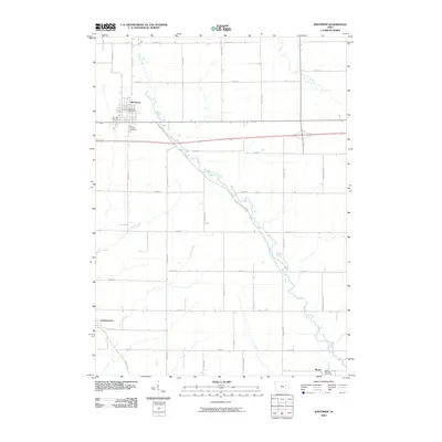
2010 Map of Winthrop
USGS Topo · Published 2010About this map
Buffalo Creek defines the local topography of eastern Buchanan County, winding southeast from the community of Winthrop through a landscape governed by the Jeffersonian grid. The settlement of Winthrop serves as the primary hub, where the Winthrop Post Office and nearby Fairview Cemetery provide historical anchors for local genealogy. To the south and east, smaller settlements like Quasqueton and Monti appear, the latter situated near Saint Patricks Cemetery.
Find a feature on this map
39 named features on this map. Tap any name to fly to it.
Don’t see what you’re looking for? This feature index may not catch every label — zoom into the map to look around manually.
Map Details
Editions of this 2010 Winthrop Map
This is the sole edition of this map. No revisions or reprints were ever made.
Other maps of this area

1901 · Oelwein
USGS Topo · 1:125,000

1903 · Winthrop
USGS Topo · 1:125,000

1959 · Dubuque
USGS Topo · 1:250,000

1961 · Dubuque
USGS Topo · 1:250,000

1962 · Dubuque
USGS Topo · 1:250,000

1965 · Lamont
USGS Topo · 1:24,000

1965 · Dundee
USGS Topo · 1:24,000
1973 · Troy Mills
USGS Topo · 1:24,000
1973 · Quasqueton
USGS Topo · 1:24,000
1973 · Winthrop
USGS Topo · 1:24,000