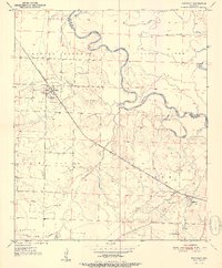
1951 Map of Winthrop
USGS Topo · Published 1951About this map
The Kansas City Southern railroad serves as the principal corridor through this southwest Arkansas landscape, connecting the town of Winthrop to the smaller settlement of Alleene. The drainage pattern is dominated by the winding course of the Little River, which forms several oxbows and backwaters including Boggy Slough and Red Lake. The terrain is divided into named areas such as Jeff Davis and Burke, reflecting local land divisions of the mid-20th century.
Find a feature on this map
22 named features on this map. Tap any name to fly to it.
Don’t see what you’re looking for? This feature index may not catch every label — zoom into the map to look around manually.
Map Details
Editions of this 1951 Winthrop Map
2 editions found
Other maps of this area

1950 · Ashdown West
USGS Topo · 1:24,000

1950 · Falls Chapel
USGS Topo · 1:24,000

1950 · Winthrop
USGS Topo · 1:24,000

1951 · Winthrop
USGS Topo · 1:24,000

1951 · Ashdown West
USGS Topo · 1:24,000

1951 · Falls Chapel
USGS Topo · 1:24,000

1951 · Arden
USGS Topo · 1:24,000

1951 · Arkinda
USGS Topo · 1:24,000

1951 · Cerrogordo
USGS Topo · 1:24,000

1951 · Horatio
USGS Topo · 1:24,000