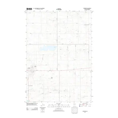
2013 Map of Winthrop
USGS Topo · Published 2013About this map
Winthrop serves as the primary municipal center in this western Sibley County landscape, where the rectilinear grid of county roads and avenues divides a terrain defined by its glacial hydrology. The area is marked by significant hydrological shifts, as evidenced by several large basins now identified as Allen Lakebed, Marsh Lakebed, and Mud Lakebed. These features, alongside Indian Lake and the winding Middle Br Rush River, illustrate a prairie environment where water management and agricultural drainage are central to the region's character. In the northeast, Saint John's Lutheran Cem stands as a focal point for genealogical interest, while the town center of Winthrop is anchored by the local Po and the intersection of MN-15 and MN-19. This modern survey documents a landscape where traditional rural structures and family farms persist within a highly organized township system.
Find a feature on this map
33 named features on this map. Tap any name to fly to it.
Don’t see what you’re looking for? This feature index may not catch every label — zoom into the map to look around manually.
Map Details
Editions of this 2013 Winthrop Map
This is the sole edition of this map. No revisions or reprints were ever made.
Other maps of this area

1953 · New Ulm
USGS Topo · 1:250,000

1957 · New Ulm
USGS Topo · 1:250,000

1958 · New Ulm
USGS Topo · 1:250,000

1958 · Gaylord
USGS Topo · 1:62,500

1958 · Winthrop
USGS Topo · 1:62,500

1964 · Bernadotte
USGS Topo · 1:24,000

1964 · Lafayette
USGS Topo · 1:24,000

1965 · New Sweden
USGS Topo · 1:24,000

1967 · New Ulm
USGS Topo · 1:250,000
1982 · Winthrop SW
USGS Topo · 1:24,000