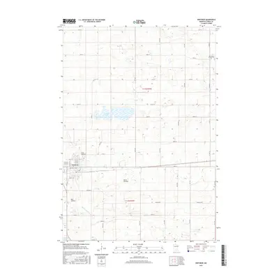
2016 Map of Winthrop
USGS Topo · Published 2016About this map
Winthrop serves as the primary hub in this portion of Sibley County, with its grid of streets such as 3rd St W and Grant St W providing a window into the town's modern footprint. The surrounding landscape is defined by its glacial history, evidenced by a series of significant depressions and wetlands including Allen Lakebed, Marsh Lakebed, and Mud Lakebed. These former lake sites, along with active water bodies like Indian Lake and Sand Lake, illustrate the complex drainage patterns of the region's agricultural prairie. To the north, Saint John's Lutheran Cem stands as a quiet marker of the local community's heritage. The area is intersected by the Middle Br Rush River, which winds through the southern townships, while a dense network of section-line roads like 260th St and Township Rd facilitates access across the rural expanse.
Find a feature on this map
28 named features on this map. Tap any name to fly to it.
Don’t see what you’re looking for? This feature index may not catch every label — zoom into the map to look around manually.
Map Details
Editions of this 2016 Winthrop Map
This is the sole edition of this map. No revisions or reprints were ever made.
Other maps of this area

1953 · New Ulm
USGS Topo · 1:250,000

1957 · New Ulm
USGS Topo · 1:250,000

1958 · New Ulm
USGS Topo · 1:250,000

1958 · Gaylord
USGS Topo · 1:62,500

1958 · Winthrop
USGS Topo · 1:62,500

1964 · Bernadotte
USGS Topo · 1:24,000

1964 · Lafayette
USGS Topo · 1:24,000

1965 · New Sweden
USGS Topo · 1:24,000

1967 · New Ulm
USGS Topo · 1:250,000
1982 · Winthrop SW
USGS Topo · 1:24,000