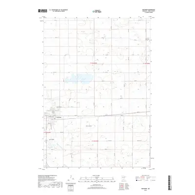
2019 Map of Winthrop
USGS Topo · Published 2019About this map
Winthrop serves as the primary hub in this Sibley County landscape, where the rectilinear grid of township roads meets the branching hydrology of the Middle Br Rush River. The map reveals a transition in the local environment, noted by several prominent basins including Allen Lakebed, Marsh Lakebed, and Mud Lakebed. These features, alongside Indian Lake and Sand Lake, illustrate the prairie pothole topography characteristic of this region. Outside the residential blocks of the town center, the landscape is defined by long-established section lines and agricultural corridors like Co Hwy 10 and 44th St. To the northeast, the Saint John's Lutheran Cem stands as a significant point of interest for genealogists and local historians tracking early families in the rural townships.
Find a feature on this map
34 named features on this map. Tap any name to fly to it.
Don’t see what you’re looking for? This feature index may not catch every label — zoom into the map to look around manually.
Map Details
Editions of this 2019 Winthrop Map
This is the sole edition of this map. No revisions or reprints were ever made.
Other maps of this area

1953 · New Ulm
USGS Topo · 1:250,000

1957 · New Ulm
USGS Topo · 1:250,000

1958 · New Ulm
USGS Topo · 1:250,000

1958 · Gaylord
USGS Topo · 1:62,500

1958 · Winthrop
USGS Topo · 1:62,500

1964 · Bernadotte
USGS Topo · 1:24,000

1964 · Lafayette
USGS Topo · 1:24,000

1965 · New Sweden
USGS Topo · 1:24,000

1967 · New Ulm
USGS Topo · 1:250,000
1982 · Winthrop SW
USGS Topo · 1:24,000