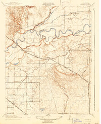
1917 Map of Winton
USGS Topo · Published 1943About this map
The Merced River meanders across this Central Valley landscape, flanked by a complex network of waterways including Ingalsbe Slough, Dana Slough, and the Old Channel. This 1917 survey captures the agricultural and transportation development of the era, defined by two major rail lines: the Atchison Topeka and Santa Fe passing through Winton in the southwest, and the Southern Pacific (Oakdale Branch) cutting diagonally through Amsterdam. Local education and community life are anchored by scattered rural institutions like Hopeton School, Amsterdam School, and Arundel School. The presence of the Yosemite Valley Canal and Canal Creek illustrates the early engineering efforts required to manage water for the region's growing settlements, which also include Edendale and the small siding at Arundel.
Find a feature on this map
19 named features on this map. Tap any name to fly to it.
Don’t see what you’re looking for? This feature index may not catch every label — zoom into the map to look around manually.
Map Details
Editions of this 1917 Winton Map
2 editions found

Other maps of this area

1893 · Sonora
USGS Topo · 1:125,000

1896 · Sonora
USGS Topo · 1:125,000

1897 · Sonora
USGS Topo · 1:125,000

1898 · Sonora
USGS Topo · 1:125,000

1913 · Dickenson
USGS Topo · 1:31,680

1914 · Merced
USGS Topo · 1:31,680

1916 · Three Tree Flat
USGS Topo · 1:31,680

1916 · Hopeton
USGS Topo · 1:31,680

1916 · Cressey
USGS Topo · 1:31,680

1916 · Montpellier
USGS Topo · 1:31,680