
1917 Map of Winton
USGS Topo · Published 1917About this map
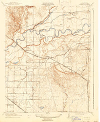
The winding Merced River anchors this 1917 study, showing a central California landscape defined by its irrigation and transportation networks. The map details the transition from riverine features like Ingalsbe Slough and Old Channel to an engineered agricultural plain. Three major rail lines converge across this territory: the Atchison Topeka and Santa Fe passing through Winton, the Yosemite Valley R. R. heading toward the foothills, and the Southern Pacific (Oakdale Branch). This rail density suggests the area’s early importance as a shipping hub for Central Valley produce. Local rural life is evidenced by a series of schoolhouses, including the Hopeton School and Amsterdam School, which served the small settlements of Arundel and Amsterdam during a period of steady agrarian development.
Find a feature on this map
17 named features on this map. Tap any name to fly to it.
Don’t see what you’re looking for? This feature index may not catch every label — zoom into the map to look around manually.
Map Details
Editions of this 1917 Winton Map
2 editions found
Other maps of this area

1893 · Sonora
USGS Topo · 1:125,000

1896 · Sonora
USGS Topo · 1:125,000

1897 · Sonora
USGS Topo · 1:125,000

1898 · Sonora
USGS Topo · 1:125,000

1913 · Dickenson
USGS Topo · 1:31,680

1914 · Merced
USGS Topo · 1:31,680

1916 · Three Tree Flat
USGS Topo · 1:31,680

1916 · Hopeton
USGS Topo · 1:31,680

1916 · Cressey
USGS Topo · 1:31,680

1916 · Montpellier
USGS Topo · 1:31,680