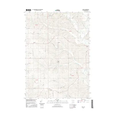
2016 Map of Wiota
USGS Topo · Published 2016About this map
Wiota and the surrounding Lafayette County countryside are defined by a network of rural roads and the meandering courses of the Yellowstone River and E Br Pecatonica River. This landscape is primarily agricultural, yet it preserves a significant record of early settlement through its numerous small burial grounds, including the Apple Grove Lutheran Cem and Miller Cem. The small village of Lamont serves as a northern anchor, while the Whoopy Hollow Aerodrome provides a modern, distinctive landmark among the ridges.
Find a feature on this map
60 named features on this map. Tap any name to fly to it.
Don’t see what you’re looking for? This feature index may not catch every label — zoom into the map to look around manually.
Map Details
Editions of this 2016 Wiota Map
This is the sole edition of this map. No revisions or reprints were ever made.
Other maps of this area

1902 · Mineral Point
USGS Topo · 1:125,000

1923 · Blanchardville
USGS Topo · 1:62,500

1923 · South Wayne
USGS Topo · 1:62,500

1954 · Rockford
USGS Topo · 1:250,000

1955 · Rockford
USGS Topo · 1:250,000

1958 · Rockford
USGS Topo · 1:250,000

1959 · Dubuque
USGS Topo · 1:250,000

1961 · Dubuque
USGS Topo · 1:250,000

1962 · Dubuque
USGS Topo · 1:250,000
1962 · Blanchardville
USGS Topo · 1:62,500