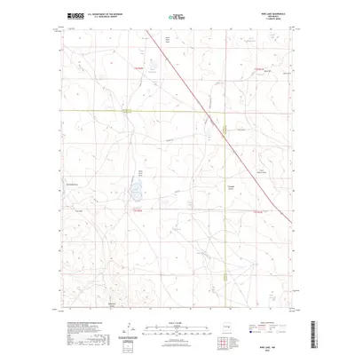
2023 Map of Wire Lake
USGS Topo · Published 2023About this map
Wire Lake and the arid basins of the Pecos Valley region define this landscape along the border of De Baca and Chaves counties. The terrain is a network of ephemeral water sources and drainage features essential for ranching, including the family-named Casaus Lake and several stock tanks like Corona Tank and Sally Tank. The 285 highway cuts a straight diagonal through the eastern portion of the quadrangle, passing near Burro Hill and crossing drainage systems such as Dead Mexican Draw and Threadgill Canyon. This survey documents a contemporary ranching environment where historical tracks like Halfway Trl and Wirelake Rd connect isolated water points like North Home Lake and South Home Lake. The landscape is further characterized by deep geographic cuts like Fifteenmile Arroyo and various livestock watering stations such as Burro Draw Tank.
Find a feature on this map
37 named features on this map. Tap any name to fly to it.
Don’t see what you’re looking for? This feature index may not catch every label — zoom into the map to look around manually.
Map Details
Editions of this 2023 Wire Lake Map
This is the sole edition of this map. No revisions or reprints were ever made.
Other maps of this area

1954 · Fort Sumner
USGS Topo · 1:250,000

1955 · Roswell
USGS Topo · 1:250,000

1958 · Fort Sumner
USGS Topo · 1:250,000

1958 · Roswell
USGS Topo · 1:250,000

1962 · Roswell
USGS Topo · 1:250,000

1967 · Wire Lake
USGS Topo · 1:24,000

1967 · Round Mountain
USGS Topo · 1:24,000

1967 · Chivata Canyon
USGS Topo · 1:24,000

1967 · Devils Well
USGS Topo · 1:24,000

1967 · Ramon
USGS Topo · 1:24,000