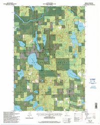
1996 Map of Wirt
USGS Topo · Published 1998About this map
Wirt stands as the primary settlement on this northern landscape, situated just south of the winding Big Fork River. This area of Itasca County is defined by a dense mosaic of lakes and complex water management systems, where the Chippewa National Forest and Bowstring State Forest meet the boundaries of the Leech Lake Indian Reservation. The map reveals a land heavily shaped by forestry and conservation, featuring numerous managed water bodies like the Holland Lake Impoundment and Fletcher Creek Impoundment. Genealogists and local historians can locate both the Wirt Cemetery near the river and the Sand Lake Cemetery further south, providing specific points of interest for family research in this township. The presence of a Gravel Pit and various ranger districts highlights the dual economy of resource extraction and federal land management that characterized the region in the late twentieth century.
Find a feature on this map
34 named features on this map. Tap any name to fly to it.
Don’t see what you’re looking for? This feature index may not catch every label — zoom into the map to look around manually.
Map Details
Editions of this 1996 Wirt Map
This is the sole edition of this map. No revisions or reprints were ever made.
Other maps of this area

1918 · Zora
USGS Topo · 1:62,500

1919 · Zora
USGS Topo · 1:62,500

1919 · Gemmell
USGS Topo · 1:62,500

1919 · Max
USGS Topo · 1:62,500

1954 · Bemidji
USGS Topo · 1:250,000

1954 · Hibbing
USGS Topo · 1:250,000

1957 · Bemidji
USGS Topo · 1:250,000

1957 · Hibbing
USGS Topo · 1:250,000

1958 · Bemidji
USGS Topo · 1:250,000

1958 · Hibbing
USGS Topo · 1:250,000