
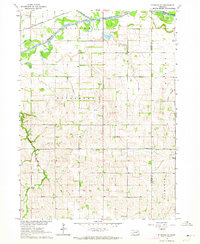
1963 Map of Wisner
USGS Topo · Published 1964About this map
Wisner anchors this Cuming County landscape, established as a vital hub along the Chicago and North Western railroad during the early 1960s. The town sits just north of the meandering Elkhorn River, which is flanked by numerous oxbow formations including Kanes Lake, Woerdeman Lake, and Raabe Lake. The surrounding rural topography is organized into traditional townships like Wisner, Bismarck, and Elkhorn, reflecting the agricultural grid typical of eastern Nebraska.
Find a feature on this map
20 named features on this map. Tap any name to fly to it.
Don’t see what you’re looking for? This feature index may not catch every label — zoom into the map to look around manually.
Map Details
Editions of this 1963 Wisner Map
This is the sole edition of this map. No revisions or reprints were ever made.
Other maps of this area

1955 · Sioux City
USGS Topo · 1:250,000

1955 · Fremont
USGS Topo · 1:250,000

1957 · Fremont
USGS Topo · 1:250,000

1958 · Sioux City
USGS Topo · 1:250,000

1958 · Fremont
USGS Topo · 1:250,000

1959 · Sioux City
USGS Topo · 1:250,000

1963 · Pilger
USGS Topo · 1:24,000

1963 · Altona
USGS Topo · 1:24,000
1963 · Stanton NE
USGS Topo · 1:24,000

1966 · Monterey
USGS Topo · 1:24,000