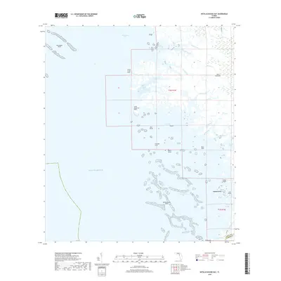
2018 Map of Withlacoochee Bay
USGS Topo · Published 2018About this map
Yankeetown serves as the primary coastal settlement on this chart of the Levy County shoreline, where the land fragmentizes into a complex network of salt marshes and tidal creeks. The geography is defined by the transition from the Big Bend's limestone shelf into the Gulf of Mexico, marked by the extensive Withlacoochee Reefs and Waccasassa Reefs. This coastal interface creates a labyrinthine environment of points and islands, including South Mangrove Point and Bird Island. Inland, the landscape is permeated by countless watercourses such as Thousandmile Creek and Eleven Prong, which drain through the wetlands toward Withlacoochee Bay. The presence of Gulf Hammock and naming conventions like Bushstake Gap reflect the region's long-standing reliance on maritime navigation and the natural resources of the Florida gulf coast.
Find a feature on this map
37 named features on this map. Tap any name to fly to it.
Don’t see what you’re looking for? This feature index may not catch every label — zoom into the map to look around manually.
Map Details
Editions of this 2018 Withlacoochee Bay Map
This is the sole edition of this map. No revisions or reprints were ever made.
Other maps of this area

1954 · Red Level
USGS Topo · 1:24,000

1954 · Gainesville
USGS Topo · 1:250,000

1955 · Lebanon Station
USGS Topo · 1:24,000

1955 · Withlacoochee Bay
USGS Topo · 1:24,000

1955 · Waccasassa Bay
USGS Topo · 1:24,000

1955 · Yankeetown
USGS Topo · 1:24,000

1955 · Sumner
USGS Topo · 1:24,000

1955 · Plant City
USGS Topo · 1:250,000

1958 · Plant City
USGS Topo · 1:250,000

1958 · Gainesville
USGS Topo · 1:250,000