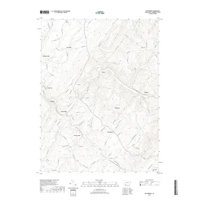
2019 Map of Wittenberg
USGS Topo · Published 2019About this map
Hays Mill and Berkleys Mill anchor the northern landscape of this Somerset County quadrangle, where the steep terrain of Big Savage Mtn shapes the local drainage and settlement patterns. The topography is defined by the winding paths of Wills Cr and Flaugherty Cr, which have historically served as natural corridors for both transportation and early industrial sites. Small clusters of residences and historical hubs like Sand Patch, Glade City, and Mance are scattered along these valleys, connected by a network of rural routes such as the Old Cumberland Pike. Local history and genealogy are well-represented by established sites like the Mount Zion-Hays Cem and Lebanon Cem. The presence of several mill sites, including Warrens Mill, suggests a legacy of water-powered industry that once supported these upland communities.
Find a feature on this map
82 named features on this map. Tap any name to fly to it.
Don’t see what you’re looking for? This feature index may not catch every label — zoom into the map to look around manually.
Map Details
Editions of this 2019 Wittenberg Map
This is the sole edition of this map. No revisions or reprints were ever made.
Other maps of this area

1898 · Frostburg
USGS Topo · 1:62,500

1899 · Grantsville
USGS Topo · 1:62,500

1901 · Frostburg
USGS Topo · 1:62,500

1904 · Grantsville
USGS Topo · 1:62,500

1908 · Frostburg
USGS Topo · 1:62,500

1921 · Meyersdale
USGS Topo · 1:62,500

1923 · Berlin
USGS Topo · 1:48,000

1929 · Berlin
USGS Topo · 1:62,500

1939 · Meyersdale
USGS Topo · 1:62,500

1944 · Berlin
USGS Topo · 1:62,500
Featured Places
- Callimont, PA
- Greenville Township, PA
- Southampton Township, PA
- Northampton Township, PA
- Warrens Mill, Greenville Township