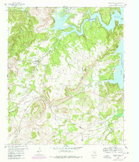
1960 Map of Wizard Wells
USGS Topo · Published 1978About this map
Wizard Wells sits at the heart of this North Texas landscape, a community once renowned for its mineral waters. By the mid-20th century, the map reveals a town and its surrounding rural character defined by small homesteads, the Wizard Wells Ch, and several family burial grounds including Wizard Wells Cem and McDaniel Cem. The eastern portion of the sheet is dominated by the sprawling waters of Lake Bridgeport, which flooded the local topography up to the Spillway Elev 825 mark. The terrain is marked by distinctive drainages and high points like Bear Knob and the rugged Devils Den. An Abandoned Railroad Grade winding through Vineyard towards the county line reflects the shifting transportation patterns of Jack and Wise counties as the regional rail economy gave way to oil and gas exploration.
Find a feature on this map
24 named features on this map. Tap any name to fly to it.
Don’t see what you’re looking for? This feature index may not catch every label — zoom into the map to look around manually.
Map Details
Editions of this 1960 Wizard Wells Map
2 editions found
Other maps of this area

1954 · Sherman
USGS Topo · 1:250,000

1954 · Wichita Falls
USGS Topo · 1:250,000

1958 · Wichita Falls
USGS Topo · 1:250,000

1958 · Sherman
USGS Topo · 1:250,000

1960 · Bridgeport West
USGS Topo · 1:24,000

1960 · Gibtown
USGS Topo · 1:24,000

1960 · Wizard Wells
USGS Topo · 1:24,000
1960 · Boonsville
USGS Topo · 1:24,000
1961 · Perrin
USGS Topo · 1:24,000

1961 · Jacksboro NE
USGS Topo · 1:24,000