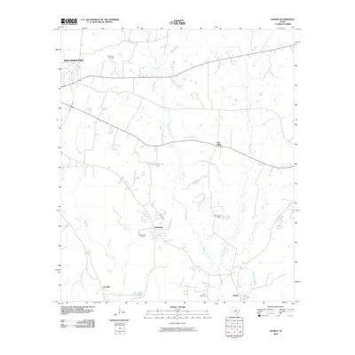
2010 Map of Woden
USGS Topo · Published 2010About this map
Nacogdoches and the surrounding rural communities of East Texas are defined by a complex network of waterways that cut through the landscape, including the prominent Bayou Carrizo and Atascoso Creek. This 2010 survey illustrates the persistence of small settlements like Fellowship, Lacyville, and Oak Ridge, which remain distinct points of interest south of the city. The area is marked by numerous family and community landmarks, providing essential data for genealogists tracing ancestors in this part of the county. Notable burial grounds such as Moroney Cemetery in the north and King Cemetery near Woden are clearly indicated. The map also highlights local water management and recreation at Kelly Lake, where the Kelly Lake Dam is situated, and the Bay Lake Club Lake near the southern boundary, reflecting the regional importance of local reservoirs and creek branches like White-Oak Branch and Puenta Suelas Creek.
Find a feature on this map
19 named features on this map. Tap any name to fly to it.
Don’t see what you’re looking for? This feature index may not catch every label — zoom into the map to look around manually.
Map Details
Editions of this 2010 Woden Map
This is the sole edition of this map. No revisions or reprints were ever made.
Other maps of this area

1949 · Lufkin
USGS Topo · 1:62,500

1949 · Platt
USGS Topo · 1:24,000

1950 · Platt
USGS Topo · 1:24,000

1950 · Redland
USGS Topo · 1:24,000

1952 · Nacogdoches
USGS Topo · 1:62,500

1953 · Palestine
USGS Topo · 1:250,000

1957 · Palestine
USGS Topo · 1:250,000

1958 · Broaddus
USGS Topo · 1:62,500

1958 · Martinsville
USGS Topo · 1:62,500
1983 · Nacogdoches South
USGS Topo · 1:24,000