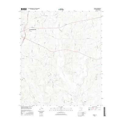
2016 Map of Woden
USGS Topo · Published 2016About this map
Nacogdoches sits at the western edge of this landscape, where the urban street grid transitions into the creeks and ridges of the East Texas piney woods. The 2016 survey documents the community of Woden in the south, connected by a network of farm roads and county routes that skirt the numerous drainages feeding into Bayou Carrizo. Local history and family genealogy are anchored by several small burial grounds, including Moroney Cem, Fellowview Cem, and King Cem. The topography is defined by its water system, with Atascosa Cr and Puenta Suelas Cr carving through the terrain. Significant local features such as Kelly Lake and Bay Lake Club Lake provide landmark points among the winding roads like Center Rd and Upper Melrose Rd.
Find a feature on this map
72 named features on this map. Tap any name to fly to it.
Don’t see what you’re looking for? This feature index may not catch every label — zoom into the map to look around manually.
Map Details
Editions of this 2016 Woden Map
This is the sole edition of this map. No revisions or reprints were ever made.
Other maps of this area

1949 · Lufkin
USGS Topo · 1:62,500

1949 · Platt
USGS Topo · 1:24,000

1950 · Platt
USGS Topo · 1:24,000

1950 · Redland
USGS Topo · 1:24,000

1952 · Nacogdoches
USGS Topo · 1:62,500

1953 · Palestine
USGS Topo · 1:250,000

1957 · Palestine
USGS Topo · 1:250,000

1958 · Broaddus
USGS Topo · 1:62,500

1958 · Martinsville
USGS Topo · 1:62,500
1983 · Nacogdoches South
USGS Topo · 1:24,000