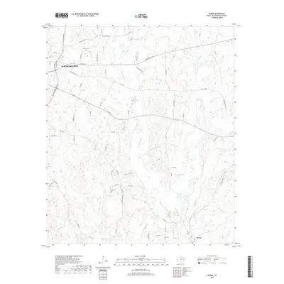
2019 Map of Woden
USGS Topo · Published 2019About this map
Nacogdoches serves as the focal point of the northwestern quadrant of this survey, where the urban grid gives way to a dense network of county roads and creek drainages. The landscape is defined by the branching tributaries of Bayou Carrizo, Atascoso Cr, and Dorr Cr, which carve through the terrain south toward the community of Woden. For family historians, the map identifies several significant burial sites, including Moroney Cem near the upper reaches of the carizzo and Fellowview Cem located just off Woden Rd. Local travel is dictated by historic corridors like Old Trinity Rd and the more modern SE Stallings Dr loop. Small recreational and agricultural water bodies like Kelly Lake and Bay-Lake Club Lake dot the lowlands, illustrating the rural character of southeastern Nacogdoches County in the late 2010s.
Find a feature on this map
70 named features on this map. Tap any name to fly to it.
Don’t see what you’re looking for? This feature index may not catch every label — zoom into the map to look around manually.
Map Details
Editions of this 2019 Woden Map
This is the sole edition of this map. No revisions or reprints were ever made.
Other maps of this area

1949 · Lufkin
USGS Topo · 1:62,500

1949 · Platt
USGS Topo · 1:24,000

1950 · Platt
USGS Topo · 1:24,000

1950 · Redland
USGS Topo · 1:24,000

1952 · Nacogdoches
USGS Topo · 1:62,500

1953 · Palestine
USGS Topo · 1:250,000

1957 · Palestine
USGS Topo · 1:250,000

1958 · Broaddus
USGS Topo · 1:62,500

1958 · Martinsville
USGS Topo · 1:62,500
1983 · Nacogdoches South
USGS Topo · 1:24,000