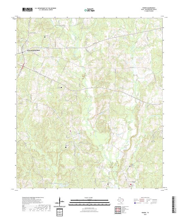
2022 Map of Woden
USGS Topo · Published 2022About this map
The rural landscape southeast of Nacogdoches in the early 2020s is defined by a dense network of country roads and creek drainages. Small settlements like Woden anchor the southern portion of the map, while numerous family and community burial grounds, including Maroney Cem and Simpson Campground Cem, point to generations of local history. The terrain is deeply carved by water, with Bayou Carrizo and its tributaries like Atascoso Cr and Puenta Suelas Cr winding through the countryside. These waterways are accompanied by small impoundments such as Kelly Lake and Bay Lake Club Lake. The mapping of Fairview Church Cem and Fellowview Cem highlights the enduring presence of rural religious and social centers amidst the timbered hills and pastures of Nacogdoches County.
Find a feature on this map
71 named features on this map. Tap any name to fly to it.
Don’t see what you’re looking for? This feature index may not catch every label — zoom into the map to look around manually.
Map Details
Editions of this 2022 Woden Map
This is the sole edition of this map. No revisions or reprints were ever made.
Other maps of this area

1949 · Lufkin
USGS Topo · 1:62,500

1949 · Platt
USGS Topo · 1:24,000

1950 · Platt
USGS Topo · 1:24,000

1950 · Redland
USGS Topo · 1:24,000

1952 · Nacogdoches
USGS Topo · 1:62,500

1953 · Palestine
USGS Topo · 1:250,000

1957 · Palestine
USGS Topo · 1:250,000

1958 · Broaddus
USGS Topo · 1:62,500

1958 · Martinsville
USGS Topo · 1:62,500
1983 · Nacogdoches South
USGS Topo · 1:24,000